
Dhaulagiri Circuit Trek Map
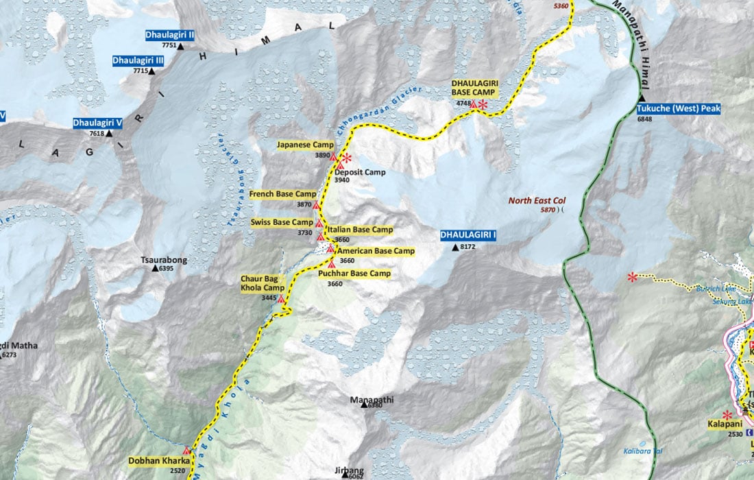
This map represented the detailed trail route that you’ll follow during Dhaulagiri Circuit Trek. It will help you to visualize the proposed trekking route with the data related to the maximum altitude, lower altitude, total distance covered, and trek duration. A detailed Dhaulagiri Circuit Trek Map will help you immensely along the remote trail of the Dhaulagiri region. It provides in-depth information about the trekking trails and major landmarks.
While the Dhaulagiri region holds various trekking courses in different directions, the trekkers' typical standard route is famous. Generally, the Dhaulagiri Circuit Trek Itinerary starts with a scenic drive from Pokhara to Beni and trek forward, passing through villages such as Babiyachaur, Darbang, Bhogara, Dobhan, Italian Base Camp, and reach Dhaulagiri Base Camp. Afterward, passing multiple high passes (French and Dhampus) via Hidden Valley, the trail descends to Jomsom. Rather than trekking back to Pokhara, you can directly fly back to Pokhara from Jomsom.
Moreover, Dhaulagiri Circuit Trek Map offers accurate information about the distance, altitude, places, etc. Along with the standard route in this map, you can also learn about the possible side trips and detours. In general, it takes about 18-20 days to complete this Dhaulagiri Circuit Trek. If you choose a different starting point, such as Darbang or Babiyachaur, the trekking days and distance might differ to some extent.
Whether you opt for a clockwise or anticlockwise direction to start this circuit trek, you can follow this online Dhaulagiri Circuit Trek Map. It is easy to comprehend. On the map, you can also witness the other popular trekking routes, such as Dhaulagiri Base Camp Trek, Ghorepani Poon Hill Trek, Khopra Ridge Trek, etc.
Additionally, the map shows a visual representation of information such as rivers, streams, hamlets, campsites, viewpoints, checkpoints, monasteries, gompas, helipads, and many more. The map covers all essential landmarks that you’ll encounter during the trek. The dark yellow dotted line in the map shows the main trekking trail, and the light dotted yellow line shows the secondary trekking trail of the region.
Further, this online Dhaulagiri Circuit Trek Map also offers other information about the trekking route such as accommodation, airport, mountain peaks, conservation area, etc. You’ll also get to learn the names and elevations of nearby peaks during the trek. You can use this digital map to plan your adventurous trek in advance and make your trip exciting and memorable.


