
Khopra Ridge Trek Map
Khopra Ridge Trek Map illustrates everything from resting grounds along the trails to peaks and primary (and secondary) trails. This online map is authentic and updated and incorporates the basic functionality of zoom in and zoom out. With the detailed trail route of Khopra Ridge Trek, this digital map can also be used for other popular treks in the Annapurna region like Mardi Himal Trek, Poon Hill Trek, and Annapurna Base Camp Trek.
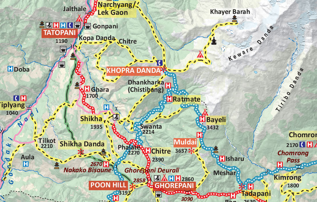
The map contains standard sets of icons, differently shaped and colored symbols that are the graphical representation of information and represents features like International Boundary, National Park Boundary, Highway, Main Road, Main Trekking Route, Secondary Trekking Route, Peaks, Temple, Monastery, Chorten, Airport, Helipad, Glacier, Rivers, Check Point and many more.
Khopra Ridge Trek is a recently opened trek in the Annapurna region of Nepal, and it wouldn't be wrong to say that it is one of the underrated treks in Nepal. The trek takes you through a secluded and serene trail brimming with stunning views of Dhaulagiri, Manaslu, Annapurna Massif, Hiunchuli, Nilgiri Himal, and other peaks. This trek was introduced in the Annapurna Region as a community trek to help raise the economic standards of the villages lying on the Khopra Danda trail.
You can complete the trek in just 10 days. The adventure to Khopra ridge begins from Kimchi after a short drive to Pokhara. The trail traverses quaint Gurung villages and dense rhododendron forests, leading through popular stopping points like Ghandruk, Dobato, Poon Hill, Ghorepani and Khopra Ridge. From Khopra Ridge, the trail slowly ascends to Khayer Lake. Finally, you'll trek to Ghorepani and Poon Hill before driving to Pokhara and flying to Kathmandu.
In order to read the map for Khopra Ridge Trek, the first thing you can do is find Pokhara and follow the red line in the east direction. Make sure to spot Kimche above Birethanti. You can easily find major places like Pokhara, Ghandruk, Poon Hill, Ghorepani, and Khopra Danda; all are written in BLOCK CAPITALS.
The map scale of this map is 1: 200,000. It means one inch of the map equals 200,000 inches of real-world terrain. You can easily identify the symbols for peaks, campsites, temples, monasteries, airports, helipads, World Heritage Site, rivers, and bridges.


