
Manaslu Trek Map
We have designed this page for Manaslu Trek Map. The digital map is quality-assured, updated, and reliable and incorporates the basic functionality of zoom in and zoom out; at the top-right corner is the plus and minus sign to zoom in and zoom out, respectively. This page is created for simplicity and practicality and to enhance your trekking experience. In addition, the map accurately portrays the trails of the Manaslu region with other geographical features like glaciers, peaks, rivers, and religious sites. You can use this map to access the trek information and details.
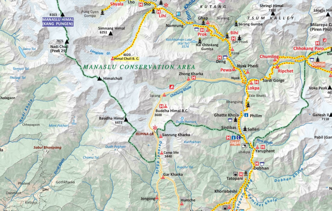
The map uses standard sets of icons, differently shaped and colored symbols that are the graphical depiction of information and represents features like International Boundary, National Park Boundary, Highway, Main Road, Main Trekking Route, Secondary Trekking Route, Peaks, Temple, Monastery, Chorten, Airport, Helipad, Glacier, Rivers, Check Point and many more.
Manaslu Trek is one of the unique treks, popular for picturesque lowland valleys, mountain cultures, ancient monasteries, and mountain passes. The less-trodden path through the mystical valleys and glaciers is equally challenging and exhilarating. One of the perks of trekking in the Manaslu region is that the trails are less crowded and possess spectacular beauty.
Larkya La Pass-one of the highest trekking passes-is the stunning attraction of trekking in the Manaslu region. Similarly, Tsum, Budi Gandaki, Nubri, and Marshyangdi valleys are the notable highlights of the Manaslu circuit trek. Crossing high passes along the Tibet border, hiking to Manaslu Base Camp, or a side hike to Birendra Lake at 3620m and Kalmachum Lake at 3800 m will be the memorable part of the adventure. Besides, breathtaking views of Manaslu-the 8th highest peak in the world, Mt Ganesh, Mt Sringi, and Mt Boudha ranges are what lures trekkers to this region.
Please be informed that you need to drive from Kathmandu or Pokhara to Soti Khola or Barpak. There are no flights to Manaslu and Tsum valley. Unlike Everest, Annapurna, and Langtang regions, the treks in the Manaslu region have to be organized through local tour operators. Most Nepalese tour operators offer a 17-day Manaslu trek from Kathmandu. The Manaslu Trek itinerary lets you explore the Manaslu region's hidden valleys and tucked-away gompas.
Please acknowledge the frame (the border) enclosed in pink color as the international boundary. The glaciers are addressed in blue letters and conservation areas in green letters. The red dash line enclosed in yellow is the main trekking trail. For your information, the popular landmarks or stopping points are inscribed in highlighted-bold letters. To the bottom-left corner, the map scale of this map is 1: 300,000. It means one inch of the map equals 300,000 inches of real-world terrain. For your information, the H letter enclosed in red color represents Hotel. You can quickly identify the symbols for peaks, campsite, temple, monastery, World Heritage Site, river, and bridges. As you scroll the map to the north, you can see many (or Tal) lakes like Dona Tal, Dudh Pokhari, Kalchuman Lake, Chhengge Tal, Suti Tal, and several others.
Note: This map can be used for Tsum Valley Trek or Manaslu and Tsum Valley Trek Map.


